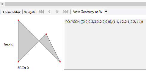
The past couple of blog entries have been on Geographic
Information Systems and Geometric Data. Visualizing that
data with MySQL Workbench makes it easier for me to see what the
results really mean.
| Workbench 8.0.15 will draw the polygon with the Spatial View Option |
So how do you get there?
Start Workbench, create a new SQL Tab in your favorite scratch
schema, and crate the table below.
CREATE TABLE `test` (
`id` INT NOT NULL AUTO_INCREMENT,
`geom` GEOMETRY NULL,
PRIMARY KEY (`id`));
Next add some data.
INSERT INTO `test` …